St. Elizabeth of Hungary Catholic Church is a visual terminus down Arapahoe. Kara Pearson Gwinn
As Larimer Street crosses Cherry Creek, it does a slight jog. Kara Pearson Gwinn
One source of confusion is whether the streets run north-south or east-west. Kara Pearson Gwinn
The grids intersect in Five Points, Uptown and La Alma/Lincoln Park. Google Maps
The street grid Denver was born with in the 1850s became the exception to the rule as the city grew around it in the subsequent decades. The askew layout has both drawbacks and benefits.
Just about everyone is aware of downtown Denver's diagonal street pattern that collides with the U.S. survey-aligned grid of the surrounding metro area, creating a corridor of five-pointed intersections and triangular blocks.
Less known is that the original downtown itself is laid out on two separate grids. Auraria City was settled in 1858 along the south bank of Cherry Creek. Mere weeks later on the other side of the creek, Denver City was established, but it was aligned with the South Platte River.
"They were mining camps, and people wanted access to water for sluicing or panning," says CU Denver history professor Tom Noel, a.k.a. "Dr. Colorado." "Denver started out as a mining camp when a little bit of gold was discovered in Cherry Creek and the South Platte."
It so happens that Cherry Creek and the South Platte converge at almost an exact 90-degree angle, so the street grids of the two rival settlements, which were united in 1860, appear today as one seamless grid to the casual observer.
But, says longtime planning consultant and blogger Ken Schroeppel, "They're slightly different. Take a close look at what the downtown grid does at Cherry Creek, and you'll notice that all the named streets like Larimer and Curtis and Lawrence, when they cross Cherry Creek, they do a slight jog, about one degree. And that's because one grid was laid out to be parallel with the creek; the other was laid out to be parallel with the river."
Order comes to boomtown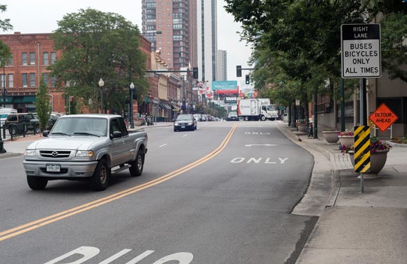
![]() As Larimer Street crosses Cherry Creek, it does a slight jog.
A conventional north-south grid pattern -- a real contrast to the diagonal grid -- began to take shape in 1864 when the first streets outside the original downtown were laid out parallel to the cardinal directions in accordance with federal government surveying.
"The country was expanding, and to avoid disputes as the land was split up, a governmental survey was created, and the whole country was surveyed this way," says Patrick Armbrust, founder and director of the Armbrust Real Estate Institute. "Our street patterns in Denver are laid out on these survey lines."
Armbrust remains a teacher as well as Denver real estate historian, and students in his real estate class are treated to tidbits they're unlikely to ever use in a real estate transaction except to impress clients, such as: "The center of Colorado Boulevard is exactly 408 miles due west of the seventh principal meridian, which runs north and south through Lincoln, Nebraska." Students also learn that Bonnie Brae was "Denver's first modern subdivision," as Armbrust reasons that it was the first neighborhood with streets off Denver's main grid.
But let's go back downtown.
Schroeppel, who runs the websites DenverInfill.com
As Larimer Street crosses Cherry Creek, it does a slight jog.
A conventional north-south grid pattern -- a real contrast to the diagonal grid -- began to take shape in 1864 when the first streets outside the original downtown were laid out parallel to the cardinal directions in accordance with federal government surveying.
"The country was expanding, and to avoid disputes as the land was split up, a governmental survey was created, and the whole country was surveyed this way," says Patrick Armbrust, founder and director of the Armbrust Real Estate Institute. "Our street patterns in Denver are laid out on these survey lines."
Armbrust remains a teacher as well as Denver real estate historian, and students in his real estate class are treated to tidbits they're unlikely to ever use in a real estate transaction except to impress clients, such as: "The center of Colorado Boulevard is exactly 408 miles due west of the seventh principal meridian, which runs north and south through Lincoln, Nebraska." Students also learn that Bonnie Brae was "Denver's first modern subdivision," as Armbrust reasons that it was the first neighborhood with streets off Denver's main grid.
But let's go back downtown.
Schroeppel, who runs the websites DenverInfill.com and
DenverUrbanism.com and is an instructor in the University of Colorado Denver's planning and design department, says the contrasting diagonal and conventional grids provide visual opportunities where they converge.
"If Denver's downtown was on the same grid as the metro area around it, then if you were looking down 16th or 17th street or Champa or any downtown street, there would never be a visual terminus," Schroeppel says. "You'd be able to see miles and miles off into the horizon. But because of the downtown grid being rotated relative to the grid around it, where those grids collide you end up with these great opportunities for a building to be located at the center of those street sight lines. So that's a really cool thing from an urban planning and urban design perspective."
Compass chaos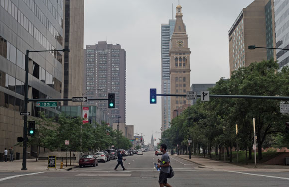
![]() St. Elizabeth of Hungary Catholic Church is a visual terminus down Arapahoe.
If there's one persistent source of confusion, it's that the downtown grid's slant is almost exactly 45 degrees, so there's not a clear consensus whether the streets run north-south, or east-west.
"When you read Phil Goodstein's book, Denver Streets
St. Elizabeth of Hungary Catholic Church is a visual terminus down Arapahoe.
If there's one persistent source of confusion, it's that the downtown grid's slant is almost exactly 45 degrees, so there's not a clear consensus whether the streets run north-south, or east-west.
"When you read Phil Goodstein's book, Denver Streets, which is the definitive source on Denver's street grids and street names, he says that the convention stretching way back to the 1800s was that the numbered streets are said to run north and south, and that the named streets are said to run east and west, if you had to pick a cardinal direction," Schroeppel says. "And then in 2007 they were doing the Downtown Area Plan, and the consultants who were working on the plan, I guess weren't aware of that convention. At least on some of the drafts I had seen, they had switched that around. They referred to such things as 'heading north on Larimer Street.' And during the Union Station development, we talked about the 'North Wing building' and the 'South Wing building.' Well, that only makes sense if the numbered streets were running east-west. But that's opposite the convention.
"I guess the point is, through a coincidence of geography, the Platte River and Cherry Creek happen to flow at almost exactly a 45 degree angle to the cardinal directions, and therefore, after 158 years, we still don't really have any consensus as to which way those streets run if you were forced to have to declare north, south, east or west."
Rich Grant, who retired last year after 35 years as communications director at Visit Denver, says it's Denver residents, not visitors, who seem most vexed by the downtown grid. "Visitors just take it in stride," Grant says. "It's only residents trying to drive who are maddened by the one-way streets and crazy turns you sometimes have to make.
"The most people I have encountered who are annoyed by the grid are usually people heading to court who were told it was at 14th and Bannock," Grant adds. "Because 14th Street turns into Bannock, lots of people get confused at the corner." (A trip to court in itself might be a source of annoyance, too, Grant is reminded.)
Despite any confusion it causes or disagreement on which way the streets run, Schroeppel says of the diagonal downtown grid, "I'm happy it exists the way it is. I think having the downtown grid rotated to everything else around it sets downtown apart and makes it unique. It makes it somewhat confusing for visitors and newcomers. That's a good thing. Not that I want to impose confusion on people, but when people are presented with something that's a little different, it makes them pay attention, and I think that elevates in their mind that they're in this special place, because they're having to change their normal navigational system in their head and have to kind of deal with things that are a little different. And I think that's good because they're viewing downtown as this special place, in part because of its rotated grid. But Denver IS a special place. By definition, downtowns are typically very unique and important places in a community. And the fact that Denver has this rotated grid even adds to that sense of uniqueness."
Photos by Kara Pearson Gwinn.
Enjoy this story?
Sign up for free solutions-based reporting in your inbox each week.
Read more articles by Mike Taylor.
Mike Taylor is a freelance writer in Denver. He is editor of
ColoradoBiz magazine and previously wrote for
The Fort Worth Star-Telegram and
The Anchorage Times.